
Low Risk for Severe Weather Wednesday Afternoon and Evening
- Austin Gagnier
- Jul 16, 2025
- 1 min read

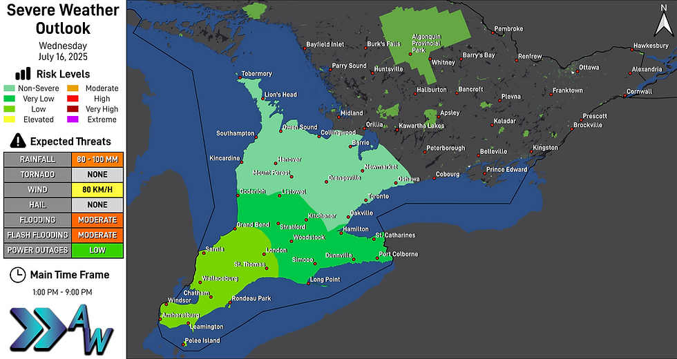
There will be a Low risk for severe weather Wednesday afternoon and evening. The main threat will be torrential downpours.
The Low risk area includes much of Southwestern Ontario. During the afternoon and evening hours, showers and thunderstorms will track through the area. Due to high humidity, torrential downpours are expected, bringing the risk for flooding and flash flooding in low lying areas. Upwards of 80 to 100 millimetres may fall in some areas. Gusty winds up to 80 km/h will be possible.
Further east, the risks will diminish, likely bringing the risk for torrential downpours, but rainfall amounts are expected to be lower.
There may be a second round of thunderstorms that affects the area late in the evening and into the overnight hours, bringing a further risk for rainfall and strong wind gusts.
Risk Levels, Threats and Locations
Low (Light Green)
Locations: Amherstburg, Chatham, Grand Bend, Leamington, London, Pelee Island, Rondeau Park, Sarnia,St. Thomas, Wallaceburg and Windsor
Threats: Rainfall of 80 to 100 millimetres, localized flooding and potential flash flooding due to torrential downpours, and wind gusts up to 80 km/h.
Very Low (Green)
Locations: Dunnville, Goderich, Hamilton, Kitchener, Listowel, Long Point, Port Colborne, Simcoe, St. Catharines, Stratford and Woodstock
Threats: Rainfall of 60 to 80 millimetres, torrential downpours, and the risk for flooding.
Non-Severe (Seafoam)
Locations: Barrie, Collingwood, Hanover, Kincardine, Lion's Head, Mount Forest, Newmarket, Oakville, Orangeville, Oshawa, Owen Sound, Southampton, Tobermory and Toronto
Threats: Heavy rainfall.


