
Rain and Thunderstorms to Start the Week
- Advance Weather

- Jun 5, 2022
- 1 min read
A stationary boundary will move into the region Monday, bringing heavy rainfall and scattered thunderstorms over the course of Monday through Tuesday afternoon.
Environment and Climate Change Canada has issued Special Weather Statements where heavy rainfall is expected over the next two days. Non-severe thunderstorms are also possible. More details are available here.

Rain will begin in parts of Central Ontario around 1:00 AM on Monday morning before pushing into Eastern Ontario between 6:00 and 7:00 AM. The rain will continue throughout the day, heavy at times, with the potential for a few breaks in Eastern Ontario, primarily mid-day before the rain moves in once again.
Southwestern Ontario will begin seeing rain between 5:00 PM and 7:00 PM, heavy at times, continuing until Tuesday morning.
Our Rainfall Forecast is below.

The heaviest rain will be in areas near Georgian Bay. Rainfall amounts will be locally higher in thunderstorms. The area breakdown is below.
50 to 60 mm: Tobermory, Owen Sound, Wiarton, Parry Sound, Bracebridge, Huntsville
40 to 50 mm: Goderich, Kincardine, Hanover, Collingwood, Barrie, Orillia, Midland
30 to 40 mm: Windsor, Leamington, Chatham, Sarnia, London, Woodstock, Kitchener, Orangeville, Newmarket, Peterborough, Bancroft, Barry's Bay
20 to 30 mm: Simcoe, St. Catherines, Hamilton, Toronto, Coburg, Belleville, Kingston, Cornwall, Ottawa
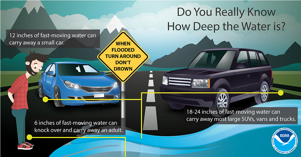
With the heavy rain expected, washouts and flooding on roads will be possible. If you encounter flooding while driving, remember to TURN AROUND, DON'T DROWN (National Weather Service). If a road is closed due to flooding, do not attempt to drive around the barricades.
Below is an infographic from the National Weather Service.
This page, including the forecast, will be updated if deemed necessary.


