
STORM CENTRE: December 28-30, 2025
- Advance Weather

- Dec 28, 2025
- 2 min read
Updated: Dec 30, 2025

***THIS STORM CENTRE HAS NOW ENDED AND WILL NO LONGER BE UPDATED. FOR THE MOST RECENT INFORMATION, PLEASE VISIT OUR HOME PAGE TO FIND THE MOST RECENT POST.***
LAST UPDATE: 2:00 PM, December 29 2025
NEXT UPDATE: 10:00 PM, December 29 2025
Discussion

An intense and dynamic winter storm has set it's sights on Southern Ontario to end the year, and impacts will begin Sunday.
Freezing Rain will be the primary hazard for Central and Eastern Ontario. Freezing Rain will begin developing in Midwestern Ontario late in the morning and spread eastward towards Eastern Ontario by the afternoon and evening. Rain may mix in at times with temperatures near the freezing mark. Severe ice accretion is expected, along with power outages and tree damage. Slippery conditions will likely develop on roadways and sidewalks, especially if untreated.
For Southwestern Ontario and areas off Lake Huron, rain is expected through much of the day Sunday. Periods of heavy rain will be possible at times, as well as thunderstorms. Flooding will be possible. Periods of freezing drizzle also cannot be completely ruled out, which may lead to icy conditions developing.

A rapid drop in temperature is expected Monday morning from west to east, leading to a flash freeze event where any residual moisture turns to ice very quickly. Roadways and sidewalks will become ice covered quickly.

Blizzard conditions are likely for areas off Lake Huron and Georgian Bay as snow squalls develop on Monday. The snow combined with the strong wind gusts near 100 km/h is expected to create extensive blowing and drifting snow, along with blizzard conditions. Road closures, some which may be prolonged, and dangerous travel conditions are expected. Avoid travel if possible. Roads may become impassable.
Snow squalls are expected for portions of Southwestern, Midwestern and Central Ontario. Snowfall amounts of 5 to 15 centimetres are likely, and due to the strong wind gusts, blowing and drifting snow will impact travel. Road closures are possible.
For the rest of the region, snow is expected. Narrow bands of heavy snow may cause rapidly reduced visibility due to strong wind gusts. Snowfall amounts of Trace to 5 centimetres are expected.
Widespread power outages are also likely due to the strong wind gusts, especially for areas that receive significant freezing rain ahead of the strong wind gusts.
Freezing Rain Outlook

Rainfall Outlook

Snow Squall Outlook

Wind Outlook


Power Outage Outlook

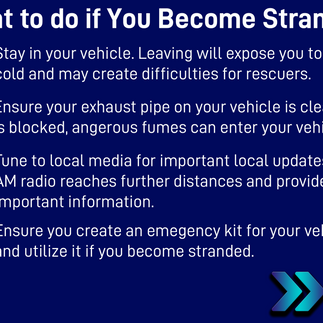
Safety Information


Closings and Cancellations
Road Closures
Transit Notices
No data has been posted.


