
STORM CENTRE: February 15-16, 2025
- Advance Weather

- Feb 15, 2025
- 2 min read
Updated: Feb 16, 2025

LAST UPDATE: 9:45 AM, February 16 2025
NEXT UPDATE: 1:00 PM, February 16 2025
Discussion
A second impactful winter storm will be the story for the weekend, bringing some additional significant snowfall to the region.
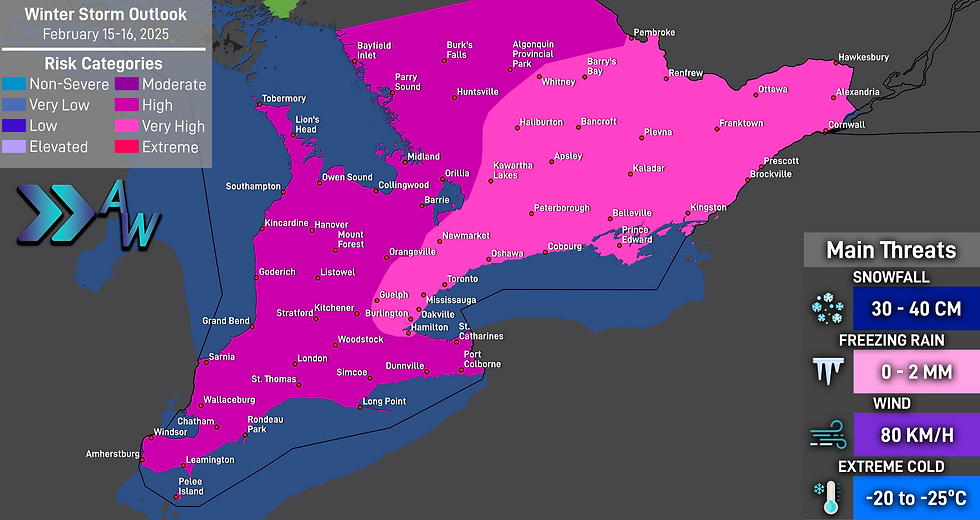
This storm will come with two parts - some snow Saturday, but the bulk of the snow will be coming on Sunday, which will lead to snowfall totals quickly piling up. Areas in Eastern Ontario are expected to see 35 to 40 centimetres of snow by the time the system departs late Sunday and early Monday morning.
Snow will begin moving into the area Friday night into Saturday morning, bringing snowfall through much of the day. bringing up to 10 centimetres, possibly 15 centimetres to many areas. Midwestern and Southwestern Ontario will begin seeing a break in the snowfall by the afternoon and evening, but overnight into Sunday morning it will begin once again.
During the breaks in the snow, it is possible that some freezing drizzle may develop, leading to icy conditions developing on roadways and sidewalks. As well, the northern shore of Lake Erie may see ice pellets and freezing rain, leading to some lower snowfall totals.
By Sunday, the region will be covered in snowfall, heavy at times, leading to travel disruptions. Strong wind gusts will begin developing, with gusts of 80 to 90 km/h in Eastern Ontario. The entire region is expected to see blowing and drifting snow, as well as poor visibility. Blizzard conditions are a true possibility. Snowfall rates on Sunday may approach or rise above 5 centimetres per hour, making it very difficult for road crews to keep up. Some roads may become impassable due to the rapidly accumulating snowfall and strong wind gusts.
Road closures are expected, and travel is expected to become difficult. Consider postponing travel on Sunday.
Some thundersnow will even be possible with this system, bringing the chance for thunder and lightning to occur while the snow is falling.
Conditions will begin improving Sunday evening, but some lake effect snow and leftover snow showers are expected to impact the region.
Winter Storm Outlook
IMPORTANT: The most hazardous conditions are expected Sunday.
Snowfall Outlook
IMPORTANT: As stated, the bulk of the snowfall will be Sunday through Monday morning. This outlook includes snowfall for the entire event, including Saturday.

Wind Outlook
IMPORTANT: Although strong wind gusts are expected Saturday, the strongest wind gusts are expected on Sunday.

Weather Alerts in Effect

What is a Blizzard?

School Bus Cancellations
No data has been posted.
Closings and Cancellations
No data has been posted.
Road Closures
No data has been posted.
Transit Notices
No data has been posted.


