
STORM CENTRE: January 18-23, 2026
- Advance Weather

- Jan 22
- 2 min read
Updated: Jan 24

THIS STORM CENTRE HAS NOW BEEN DEACTIVATED. FOR THE MOST UPDATED INFORMATION, PLEASE VISIT OUR HOME PAGE.
LAST UPDATE: January 24, 2026 | 10:30 AM
NEXT UPDATE: ---

Discussion
Snow squalls will continue affecting portions of the snowbelt regions Friday, with up to 50 centimetres possible for some areas by the end of the day.
Extreme cold will be the main story for Friday, as wind chills will be near -30ºC for many areas through the morning and afternoon hours. The coldest wind chills are likely Friday night into Saturday morning, where portions of Central Ontario will likely see wind chills fall below -35ºC. Ensure you are adequately dressed for the cold temperatures. Bring pets indoors.
Throughout the day Friday, wind gusts of 50 to 60 km/h are expected across the region. Blowing and drifting snow is likely once again. Poor visibility and poor road conditions will be expected through the day, and road closures may be possible.
Snow squalls are expected to continue Saturday, however amounts are yet to be confirmed. Wind chills for Saturday afternoon are expected to moderate slightly, with many areas seeing wind chills near -20ºC.
Some widespread snow will be possible Sunday into Monday, however many details remain uncertain.
Extreme Cold Outlook - Friday Afternoon
THIS OUTLOOK IS NOW EXPIRED.

Extreme Cold Outlook - Friday Night into Saturday
THIS OUTLOOK IS NOW EXPIRED.

Snow Squall Outlook - Friday
THIS OUTLOOK IS NOW EXPIRED.

Wind Outlook - Friday
THIS OUTLOOK IS NOW EXPIRED.

Snow Squall Outlook - Thursday
THIS OUTLOOK IS NOW EXPIRED.

Wind Outlook - Thursday
THIS OUTLOOK IS NOW EXPIRED.

Snowfall Outlook - Wednesday
THIS OUTLOOK IS NOW EXPIRED.

Wind Outlook - Wednesday
THIS OUTLOOK IS NOW EXPIRED.

Snow Squall Outlook - Tuesday
THIS OUTLOOK IS NOW EXPIRED.

Snow Squall Outlook - Sunday and Monday
THIS OUTLOOK IS NOW EXPIRED.

Wind Outlook - Monday
THIS OUTLOOK IS NOW EXPIRED.

Extreme Cold Outlook - Tuesday
THIS OUTLOOK IS NOW EXPIRED.

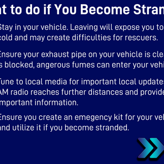
Safety Information


School Bus Cancellations
Closings and Cancellations
No data has been posted.
Road Closures
Transit Notices
No data has been posted.


